
Swamp Point – Sand & Gravel
Overview
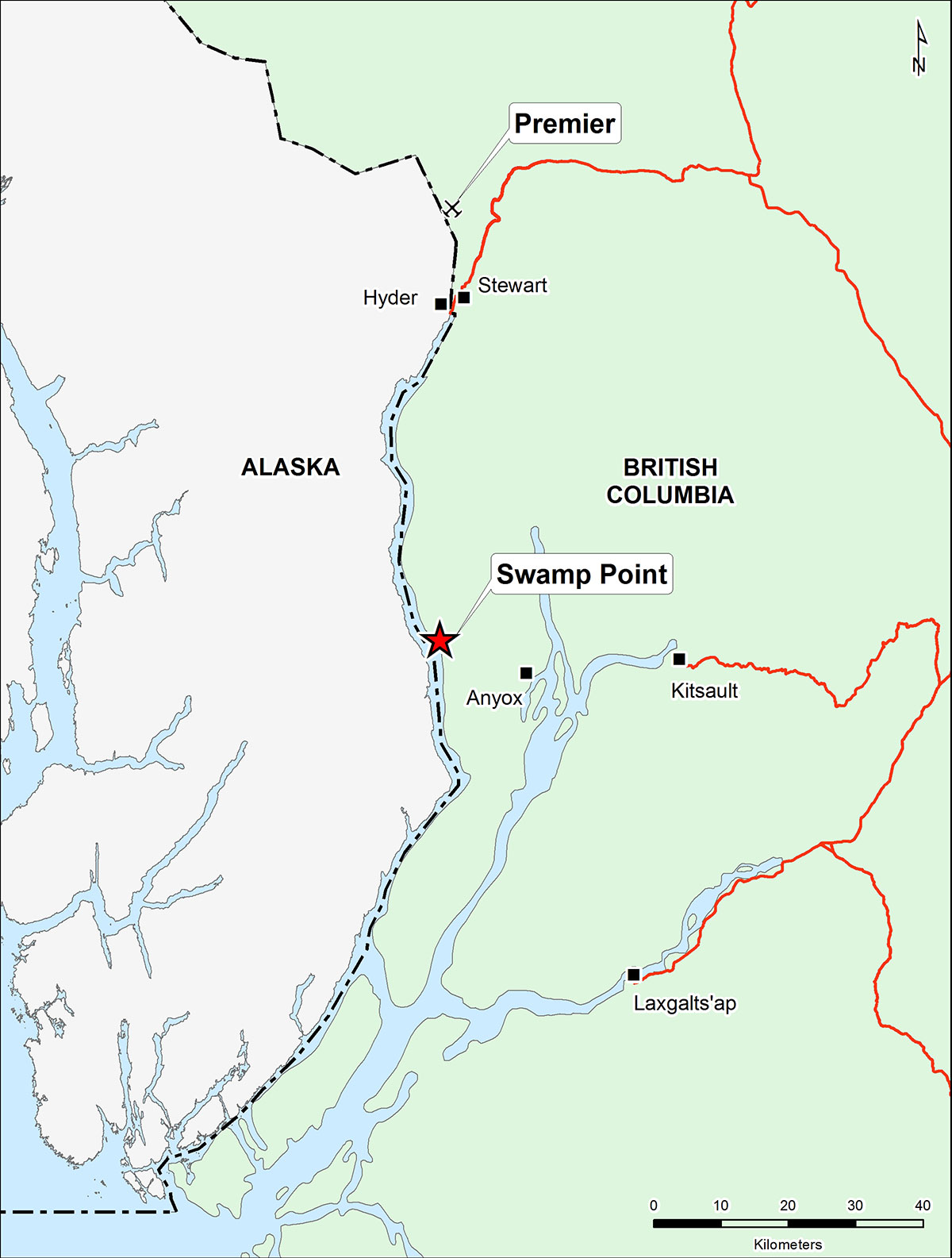 The Swamp Point aggregate deposit is located on the east side of the Portland Canal, which is a large fjord that separates British Columbia from the Southern Alaska panhandle on the northern coast of British Columbia. The port city of Prince Rupert is approximately 130 kilometres south of Swamp Point and is the closest major supply centre with an airport that has regular scheduled flights to and from Vancouver.
The site includes a Foreshore License for a deep-water port that can accommodate Panamax vessels and can be accessed by boat, float plane and helicopter either from Prince Rupert or Stewart (~50 km). Deep water shipping on the Portland Canal gives access to the Pacific Ocean, about 128 km from the port.
Ascot owns 100% of the License of Occupation, which covers the sand and gravel deposit where the project is based, and the Foreshore License, which covers part of the foreshore area beside the deposit, and two mineral claims which in part underlie the gravel deposit. The property is subject to two royalties; one to the BC Provincial Government and one to the former management of Ascot. There was limited production (~145,000 tonnes) in 2007, however, the project was put on care and maintenance shortly after as a result of the economic downturn. The mine is permitted for 3.3 million tonnes of aggregate production per annum through to 2021.
Regional Geology
The Swamp Point area is underlain by the western margin of a 14 by 10 km roof pendant within the Tertiary Coast Plutonic Complex. The rocks are commonly correlated with the Lower Jurassic Hazelton Group and are comprised of mafic and intermediate volcanic interbedded with felsic tuff, siltstone, silty argillite, fine grained sandstone and limestone.
Aggregate Deposit
Swamp Point is a glaciofluvial deposit occurring as terrace or plateau-like structures that overly the bedrock facing the coast. The deposit consists of colluvial sand and gravel, dominantly sand and pebbly sand, is moderately well sorted and moderately well stratified.
History of the Property
A geophysical survey of the target area was conducted in December 2002. Seven seismic lines totaling 4.2 km were completed. This was followed up with two phases of drilling. In March 2003, 9 Becker drill holes totaling 402 m in depth were completed and 4 test pits using a tracked excavator were excavated. Hole depths ranged from 10 to 84 m. A second phase of drilling was undertaken by Ascot in 2005. Thirteen holes totaling 596 m were drilled using a Becker Hammer drill. Approximately 20,000 kg of material from the 2005 drill holes and trenches were sent to quality material testing. In January of 2006, Hatch Ltd. and Golder Associates Ltd. completed a 43-101 pre-Feasibility technical study, which identified a 46 million tonnes measured resource grading 51% sand and 44% gravel, and that the sand and gravel material meets or exceeds typical Canadian and American specification requirements.
Management’s Outlook
Ascot acquired the aggregate project in 2002 to access potential local markets such as the port expansions in Prince Rupert along with the California markets, which were quickly running out of local supply, and surface transport costs were much higher than seaborne transport.
The site has some existing onsite infrastructure, giving it the advantage of being able to re-start within a short lead time, with some further site preparation required.
Why builders of big L.A. projects are making concrete with gravel and sand shipped from Canada
